

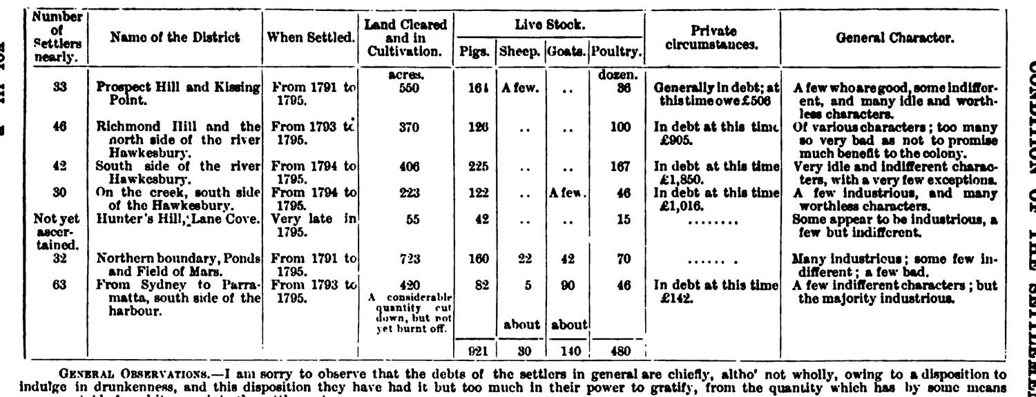
In August 1796 the Governor of New South Wales sent London a stocktake of his colony. Against the district he called “Hunter’s Hill, Lane Cove”, he recorded fifty-five acres cleared, forty-two pigs and fifteen dozen poultry. Under the column headed General Character, his assessment of the people living here: “Some appear to be industrious, a few but indifferent.”
That page is the oldest thing we could find with the name Lane Cove on it. Ask the internet where the name came from and you get three confident answers. It honours John Lane, a London merchant and a friend of Governor Arthur Phillip. It honours Michael Lane, a chartmaker who worked under Captain Cook. Or the mouth of the river looked like a narrow laneway. We went looking for the evidence behind all three, in the colonial despatches, the early charts, the published journals of the First Fleet officers and the local histories. Nothing connects any Lane, or any laneway, to the naming. The trail stops dead in 1796.
The earliest record is a governor’s stocktake from 1796
On 20 August 1796 Governor John Hunter wrote to the Duke of Portland in London and enclosed a table headed “General State of the different Districts of the Settlement”. It lists seven districts. The fifth reads:
Hunter’s Hill, Lane Cove.
Beside it are Hunter’s numbers. Settlers, “Not yet ascertained.” Settled, “Very late in 1795.”
Even there it does not stand alone. Hunter’s Hill was the district, the whole northern side of the harbour, and Lane Cove was a place inside it, named from the water. The name that is now a suburb across the river did not reach that peninsula until 1861.
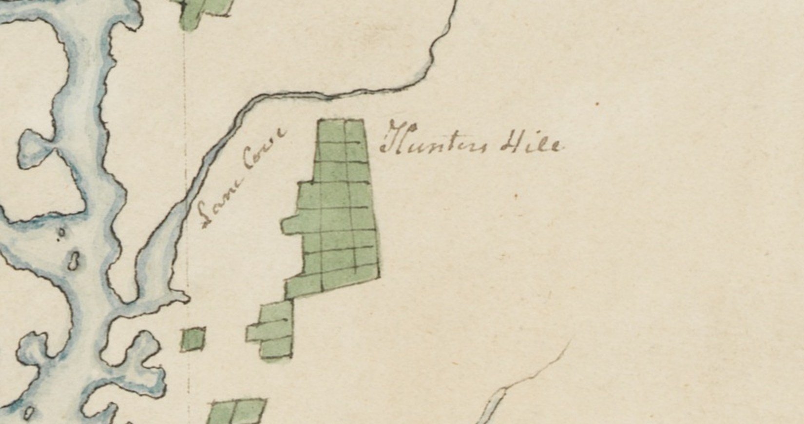
The hand-drawn chart at the top of this page went to London in the same envelope. Hunter’s own key explains the colours: “The places which are coloured green are where our principal Cultivation and farms are.” It letters Lane Cove along the water, with Hunters Hill beside it and the cleared ground washed in green.
Four months later, on 3 December 1796, a Government and General Order called a muster of every male inhabitant. The settlers of Kissing Point, Lane Cove, Bulanaming and Liberty Plains were told to attend at Sydney and be counted. Four months after the stocktake, Lane Cove was an address.
The name first reaches print in 1798, in David Collins’s account of the colony, published in London. It appears in the middle of a farce. Twenty male convicts and one woman, lately off the Queen transport from Ireland, had absconded from Parramatta with a week’s provisions, “armed with tomahawks and knives”, and “the chimerical idea of walking to China”. The officer sent after them “traced them as far down the harbour as Lane Cove”, and returned to Sydney “without seeing or hearing any thing more of them”. Collins was writing it up in London seven years later, which is why the passage dates the printing and not the name.
The trail stops in 1796, and we could not push it back
Search for the name earlier and you will not find it. It is absent from Governor Phillip’s published Voyage of 1789, from Surgeon John White’s journal, from both of Watkin Tench’s books, and from Hunter’s own Historical Journal of 1793, where the man who charted the harbour calls the waterway the north-west branch. That silence proves less than it looks. Those same documents never name Kissing Point or Bulanaming either, and Hunter’s 1788 chart leaves Farm Cove unlabelled, where the colony had been growing its first crops since 1788. All of those places existed before anyone in London wrote them down.
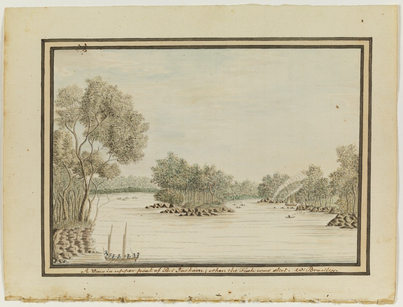
There is one apparent exception, and it is why several accounts push the name back to the First Fleet. Lieutenant William Bradley, who sounded the harbour with Hunter in 1788, kept a journal whose entry for 2 February 1788 reads “up to a Cove above (Lane Cove)”. The State Library of NSW has digitised the volume, and the parenthesis is clearly in Bradley’s own hand. It still cannot date the name. The surviving volume is a fair copy he made around 1802, fourteen years after the events, and he glosses other places the same way in it, including “(Camp Cove)”.

So the record can tell us when the name was first written down. It cannot tell us when anyone first said it, and it probably never will.
The water had a name first
The river carried a name long before any of this. The New South Wales Geographical Names Board records it as Turrumburra, with Turranburra as an alternative spelling.
The register traces it to one source, an article in a journal called Science of Man dated 1 December 1908, late and second-hand, about a much older word. Neither name’s origin is well documented, the river’s or ours. A name given by English speakers in a settlement full of clerks leaves paper, which is why a stocktake counts for anything at all. A name carried in speech leaves none, and its absence from the colonial record is a fact about who was keeping the record.
The internet’s three theories all come from one paragraph
Two of the three appear, in the same words, on Dictionary of Sydney, on Wikipedia and on the website of our state member Anthony Roberts. All three appear on the Dictionary of Sydney and across a scattering of local blogs. That looks like consensus. It is two paragraphs being copied, and both lead back to the same place.
The paragraph was written by the historian Margaret Farlow for the Dictionary of Sydney in 2011. Her entry is a careful piece of work, footnoted ten times. Not one of those ten footnotes sits on the naming paragraph. She is also more honest than the sites that copy her: “there are no primary sources which confirm one theory over another.”
That caveat is the first thing to disappear as the story travels. The older paragraph is Judy Washington’s. She wrote A Brief History of Lane Cove, revised in 1992, and Lane Cove Council put it on its website crediting her by name. Wikipedia paraphrased it in November 2004, six years before the Dictionary of Sydney entry existed. Our state member’s website still carries 647 characters of it, word for word, without the credit. Washington was the local history librarian at Lane Cove Public Library, which is how her account became the Council’s and then everyone’s.
Farlow’s laneway comes from a paper by Captain J. H. Watson, read to the Royal Australian Historical Society in 1917, and Watson is the earliest authority the local histories cite on any of this. His conclusion was blunt:
Who gave it the name, or whether the name just grew, no one knows. No one with the name of Lane can be traced who was in any way connected with it directly or indirectly.
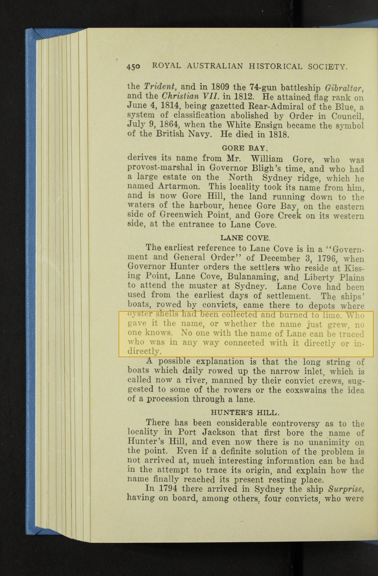
The state’s own place-names register cites Watson’s pages as authority for the John Lane theory. Those pages say no Lane can be traced.
Watson did offer a guess, but only after saying that nobody knows. He also wrote that “Lane Cove had been used from the earliest days of settlement”, which is an assertion he does not evidence. His idea was that the long string of boats that daily rowed up the inlet, manned by convict crews, “suggested to some of the rowers or the coxswains the idea of a procession through a lane”. By his account those boats were running to depots where oyster shells were burned for lime.
In 1938 Lane Cove Council published a history that dismissed the idea as anachronistic, on the grounds that the timber barges came decades later. Watson had never mentioned timber. He said lime, and his boats were convict crews. The rebuttal missed.
By 2011 the boats have vanished from the story altogether and the theory has become a claim about the shape of a river mouth. Along the way a 1970 council history by Eric Russell dropped a clause from Watson’s wording and put a “narrow” in front of the lane itself.
Watson’s lane was made of boats. By 2011 the boats have gone and the lane is the shape of the river. It is the version now on the Dictionary of Sydney and across the local blogs.
Testing the three theories
The most careful treatment of the question is not online at all. It is a four-page study by the local historian Judy Washington, “The origin of the name ‘Lane Cove’”, published in the Lane Cove Historical Society’s newsletter in February 1998. Nothing we found on the web cites it, and we could not turn up a copy from a keyboard. We joined the Society and asked. Their archivists had it to us in two days.
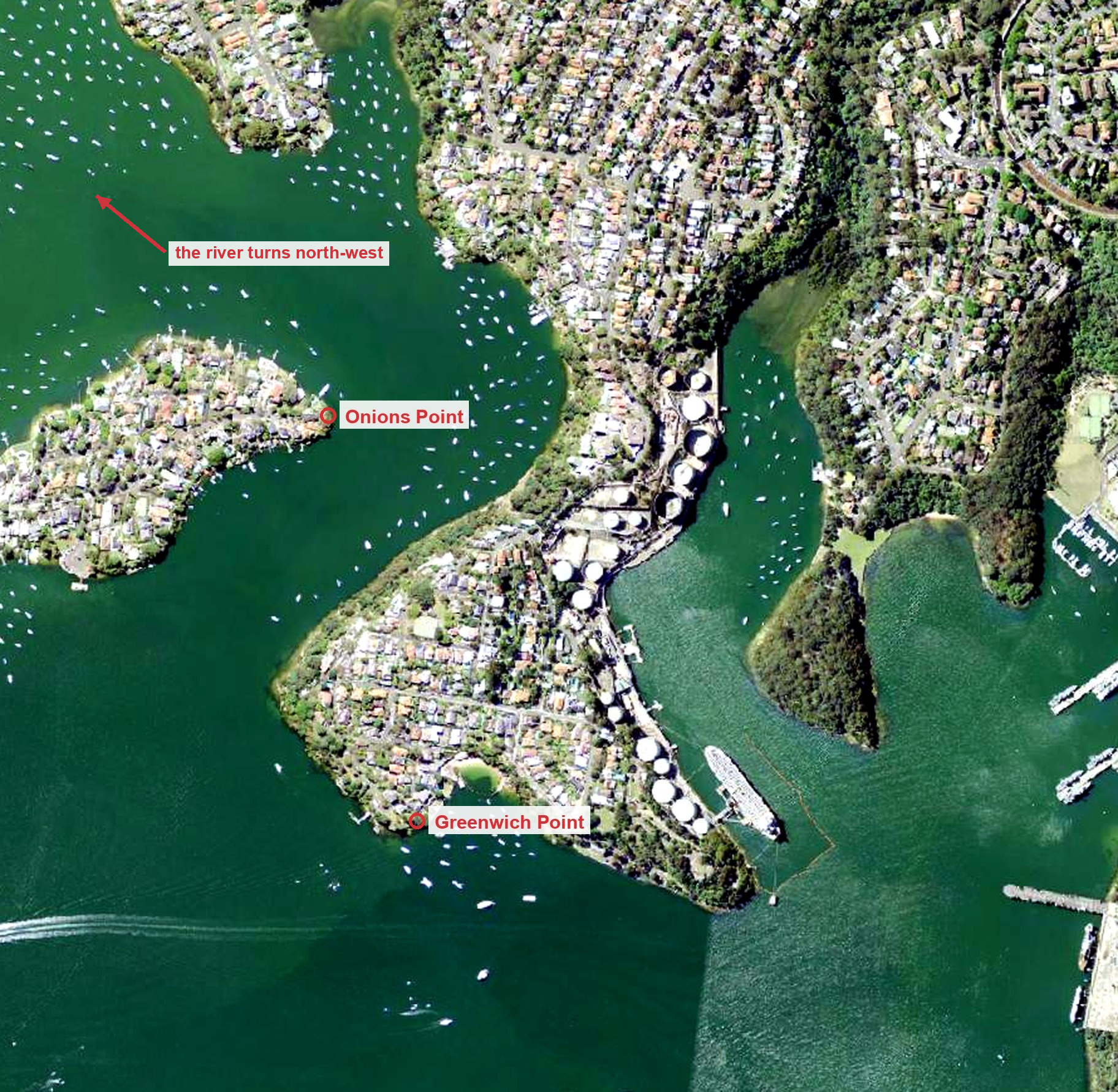
Judy Washington raised the best objection to any version of the laneway theory. In 1788 a cove meant a small indentation in a shoreline, not the entrance to a river, and Bradley was busy naming coves that February. She argues that nobody sailing past the gap between Greenwich Point and Onions Point would have known it was a river mouth: “The angle at the entrance is such that you would have to sail right into it to discover its continuation in a north-westerly direction.”
Michael Lane, James Cook’s surveying assistant
He was a real person and a serious cartographer, Cook’s surveying assistant in Newfoundland, who succeeded him as Surveyor of Newfoundland and shares the credit on the Admiralty’s published chart of 1775. The retellings call him Lieutenant Lane. He held no such rank in the Cook years. While Bradley was surveying Sydney Harbour, Lane was charting the Grand Banks.
The retellings are careless about him in a way that shows how far the story has drifted. Russell in 1970 correctly placed him in Newfoundland. Later versions moved him to “Canadian waters”. Newfoundland did not join Canada until 1949.
John Lane, Arthur Phillip’s banker
This is the strongest of the three, and the only one the Geographical Names Board commits to. It is also older than the internet makes it look: George Mackaness put it in print in 1937.
Somewhere along the way John Lane acquired a Lord Mayor for a father, and in the Dictionary of Sydney’s version that father is arithmetically impossible. He was not “the son of Sir Thomas Lane, Lord Mayor of London in 1694”. Sir Thomas died in 1709, so a son of his would have been at least a hundred and five when Phillip’s will was proved in 1814.
What is actually true about John Lane
Strip away the Lord Mayor and a documented friendship remains.
Phillip’s will, made in May 1814, names “my good friends John Lane of Nicholas Lane in the city of London merchant” among the five people he left in charge of his estate, and settles two thousand pounds in trust on Lane and then on his wife Eleanor.
The La Trobe University historian Alan Frost, in his 1987 biography of Phillip, went further. The Lane family firm, Lane, Son and Fraser of Nicholas Lane, was Arthur Phillip’s bank.

What none of that supplies is an act of naming in Port Jackson. A bank in the City of London generates wills, trusts and portraits. It does not put a word on an arm of water on the other side of the world, and Phillip had left the colony nearly four years before anyone wrote that word down.
Still looking for Mr Lane
Watson went looking for a Mr Lane in 1917 and reported that he could not find one. Nobody has found him since.
The earliest reference Watson could find was the muster order of December 1796. Yet three pages later he discusses the chart Hunter sent to London that August, footnoted to volume three of the Historical Records, and the return that carries the name, the one with the pigs in it, is printed nine pages further on in that same volume. It was in the book he was citing. The first written record of the name is four months older than the one he gave.
Watson’s other suggestion is the one that has worn best. The name may simply have grown, among boat crews and lime burners and the soldiers granted farms on the north side, in the years when the place was becoming somewhere people lived. Names do that. They rarely leave a receipt.
One document would settle all of this: anything written before August 1796 that uses the name. If you have a family paper, a parish note or an old chart with “Lane Cove” on it, we would like to hear from you at [email protected]. Somebody wrote it down first, and the odds are it is still in a box somewhere.
In the Cove acknowledges the Cammeraygal People, the Traditional Custodians of the Lane Cove area, and pays respect to Elders past, present and emerging. We also acknowledge the Wallumedegal People, whose Country connects through the waterways featured in this story.
This article was written by Anthony El-Khoury as an unpaid contributor. Data collection, analysis, and visualisations were completed with the assistance of AI, with all claims checked against the cited sources. The views expressed are his own and not those of his employer.
Sources: Hunter’s Plan of Port Jackson, 1788 (National Library of Australia, MAP NK 2456/125); “Sketch of the Settlements, 20th August, 1796” (State Library of NSW, Dixson Library, Cb 79/7); Historical Records of New South Wales, vols. II and III; David Collins, An Account of the English Colony in New South Wales (London, 1798); William Bradley, A Voyage to New South Wales (State Library of NSW, Safe 1/14, p. 74); Capt. J. H. Watson, “Origin of Place Names, Port Jackson”, Royal Australian Historical Society Journal and Proceedings, vol. IV part IX, read 1917, published 1919; George Mackaness, Admiral Arthur Phillip, founder of New South Wales (1937); 43 Years of Civic Pride (Lane Cove Municipal Council, 1938); Eric Russell, Lane Cove 1788, 1895, 1970; Alan Frost, Arthur Phillip 1738-1814: his voyaging (1987); Judy Washington, “The origin of the name ‘Lane Cove’”, Lane Cove Historical Society Newsletter no. 135, February 1998; Margaret Farlow, “Lane Cove”, Dictionary of Sydney (2011); NSW Geographical Names Register; Arthur Phillip’s will, proved 14 October 1814 (State Library of NSW, Mitchell Library, SAFE/C 213; register copy, The National Archives, PROB 11/1561/249). With thanks to the Lane Cove Historical Society, and to Dr Kay Leiper, the Society’s Vice President, who read this article after it was published and corrected it in four places.