

Lane Cove Council has been working on updating its bike plan and has released a draft Bicycle Plan. The current bike plan was adopted in 2019.
The draft Bicycle Plan (DBP) is open for public comment until 9 November 2026. After the exhibition period, Lane Cove Council staff will review submissions and present a final plan to the Lane Cove Councillors.
The full Council has not yet debated whether to adopt the 2026 bicycle plan. On 24 September 2026 Lane Cove Councillors only resolved to place the draft on public exhibition for comment.
The draft Bicycle Plan is a statement about how streets could be shared.
Lane Cove Council has set a target of more than doubling the proportion of trips made by bicycle by 2036.
Lane Cove Council’s Community Strategic Plan already prioritises walking, cycling and public transport as alternatives to driving. In March 2026, Lane Cove Council resolved to support safe, separated cycleways and investigate opportunities to reallocate road space for active transport.
The aim is to make short local trips to schools, shops, parks and the Lane Cove Village more feasible without a car.
A December 2025 site assessment prepared for Lane Cove Council found much of Lane Cove’s existing cycling infrastructure falls short of NSW design guidance, and that high-quality routes will likely require trade-offs such as reallocating parking or traffic lanes.
This is your chance to have your say. The bike plan as drafted will impact riders, walkers and drivers.
At a Glance
- The draft Bicycle Plan is on public exhibition until Monday 9 November 2026. If you are a cyclist or non-cyclist, you may still be interested in having your say on the proposed plan to be discussed by Council after the exhibition period.
- The draft proposes expanding the local cycling network from 27.5 km to more than 48 km over the next decade.
- Longueville Road through Lane Cove Village is proposed as a 10 km/h shared space, becoming one-way northbound. These are concept proposals, not final designs.
- Separated bike lanes are proposed on the regional routes linking Lane Cove to North Sydney and Hunters Hill.
- Estimated construction cost is $26.8 million (2024 dollars). The four regional routes, about $10.9 million of that, are not allocated to any delivery phase and depend on funding and the NSW Government.
- We have some great bike riding tips for riding around Lane Cove now.
Lane Cove Cycling Rates Still Low
Despite Council’s 2013 and 2019 Bike Plans, cycling in Lane Cove, according to the draft bike plan, has stayed “extremely low”.
About 1,800 trips a day are made by bike in the Lane Cove local government area (LGA). If you do want to ride your bike more, Coach Andy has some great tips in this article.
Lane Cove Council’s target is about 4,800 a day by 2036.
While current cycling rates are low, Council’s initial consultation suggests there is interest in locals riding more often. More than eight in ten survey respondents said they would like to ride more. More than seven in ten wanted to ride at least once a week, most often to the shops, work, school or for recreation.
Transport for NSW (TfNSW) research cited in the DBP puts 48% of people in the “interested but concerned” group, who would ride if conditions felt safer.
What the Site Assessment Found
In December 2025, the Institute for Sensible Transport prepared for Lane Cove Council a Site Assessment Report (site assessment). This report documents existing conditions on the 11 routes existing or proposed in the 2019 Bicycle Plan.
Two bicycle network planners rode the routes and recorded 200 observations using a mobile app, sorting them into dangerous conditions, issues, general notes and areas of opportunity.
The Site Assessment’s general findings include:
- Many proposed routes are on major arterial roads with two traffic lanes in each direction. The footpaths beside them are generally too narrow to become high-quality shared paths because of established trees, driveways and utility poles.
- With a couple of exceptions, existing shared paths in Lane Cove are narrower than would be considered suitable and are closer to a footpath than a shared path.
- Limited road space and footpath widths mean high-quality cycling infrastructure will likely require trade-offs, such as reallocating on-street parking or general traffic lanes.
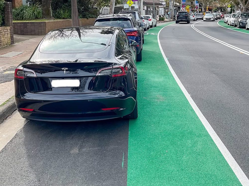
- Painted bike lanes are often too narrow and put riders between moving traffic and parked cars, exposing them to the risk of being hit by an opening car door.
- Where shared paths cross side streets, people riding have no priority.
- Speed limits are generally higher than is considered acceptable under the Safe System approach adopted by the NSW Government, on arterial roads and on residential streets with their 50 km/h default.
- Bike parking is lacking at most destinations, including commercial areas and ferry wharves, and most existing bike parking does not meet Austroads guidelines.
- Quietways are not fully realised because modal filters and traffic calming are rarely used to reduce through traffic on local streets.
- Steep topography is a significant challenge, and street design across Lane Cove consistently prioritises motor vehicle traffic over people walking and riding.
The report identifies the Epping Road cycleway as the backbone of the network. It describes it as high-quality protected infrastructure that likely carries the majority of cycling traffic in Lane Cove.
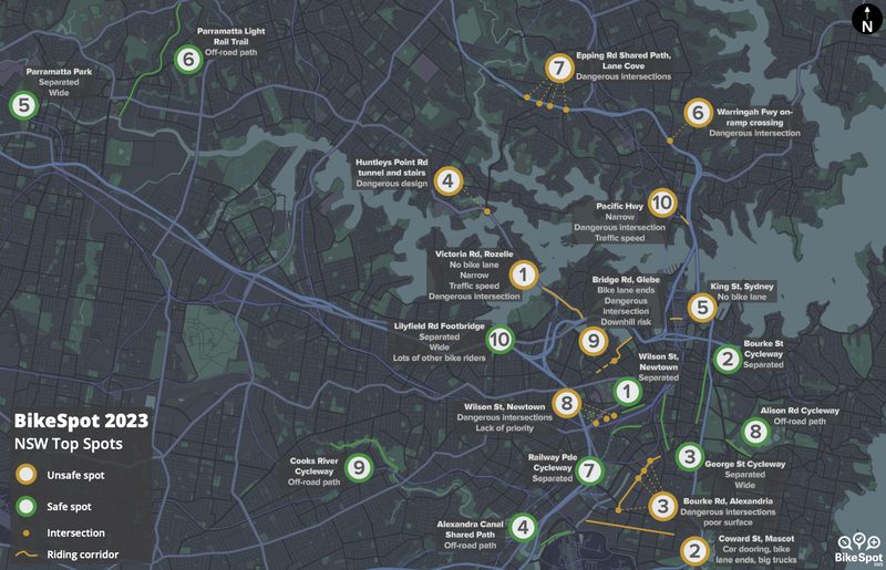
Riders have described the path differently. In December 2023, In the Cove reported that interim results from BikeSpot, a crowd-sourced cycling safety project run by the Amy Gillett Foundation and CrowdSpot, named the Epping Road cycle path in Lane Cove as the most unsafe spot to ride in NSW. Riders’ concerns centred on intersections where drivers cut across the path to turn into or out of side streets, with the Cox’s Lane, Moore Street and Munro Street intersections in Lane Cove North singled out, along with poor sight lines and a lack of signage.
These were interim results (December 2023). The final BikeSpot 2023 NSW report, released in 2024, noted Victoria Road, Rozelle as Sydney’s most-voted unsafe spot. Epping Road was 7th on the list.
A five-year summary of cyclist crashes in the 2019 Bike Plan recorded no fatal cyclist crashes in the Lane Cove local government area, but about 70% of recorded crashes resulted in moderate to serious injuries. Many involved conflict between riders and vehicles coming out of an intersection or a driveway.
Site Assessment Findings for Specific Bike Paths
The Site Assessment findings included:
Longueville Road
The painted bike lane is narrow, discontinuous and in the car-door zone, and ends at critical points such as Lane Cove Village, curves and intersections. Outside a school, cars commonly park in the bike lane.
At the northern end, riders mix with traffic and cars moving in and out of kerbside parking in a 40 km/h zone, which the report says is higher than the TfNSW Cycleway Design Toolkit recommends.
Penrose Street, Bridge Street and River Road
The shared path on the southern side of Penrose Street and Bridge Street is extremely narrow in places, has numerous driveway crossings and gives riders no priority at side streets. Combined with steep topography, the report says it may present a significant risk of serious injury or death from collisions with cars leaving driveways.
The footpath on the southern side of River Road ends abruptly at Northwood Road, forcing a dangerous crossing on a curve with high-speed traffic and no refuge.
The site assessment describes the route as regionally significant, with few alternative east–west links, and sees potential for a “super-regional” corridor from Burns Bay Road to the North Sydney CBD (about 5 km) and on to the Spit Bridge (about 10 km).
Centennial Avenue and Burns Bay Road
The report found no cycling infrastructure on this route that meets TfNSW design principles, but called the route essential to significantly increase the number of people with a safe cycling option in this part of Sydney. It sees potential for a regional route between Lane Cove, Hunters Hill and Drummoyne.
Trees, service pits and power poles leave little room for off-road paths, so safe infrastructure will likely require converting general traffic lanes into a protected bike lane.
Burns Bay Road (local section)
Between Longueville Road and Centennial Avenue, painted bike lanes sit in the car-door zone and end at bus stops and refuges, on a steep downhill stretch with a 50 km/h limit.
The ITC newsletter
Never miss what's happening in Lane Cove
Free local news in your inbox every Wednesday night. Join thousands of locals.
Tambourine Bay Road
The shared path from Burns Bay Road to Riverview Saint Ignatius College frequently narrows and has poor sight lines and numerous driveway crossings. The report says it may suit younger riders accompanied by adults but will not attract new adult riders. Read our article on the shared user path issues here.
Pacific Highway
The 2019 Plan’s short-term route on parallel local streets is described as long, indirect, circuitous and extremely steep in places. The site assessment recommends against investing in it, saying resources would be better directed to joint advocacy with neighbouring councils for an upgrade along the Pacific Highway corridor.
Mowbray Road and Centennial Avenue
The shared path on Mowbray Road is described as generally high quality, apart from a gap of about 50 metres outside Mowbray Public School.
On Centennial Avenue north of Epping Road, the report suggests converting one general traffic lane into a protected cycleway, similar to Epping Road.
The report also assessed Greenwich Road, Northwood Road and the Lane Cove Business Park. It notes that cycling is not currently permitted on the Lane Cove Valley Walk bridge to Ryde but, given low volumes, the bridge could become a valuable cross-council connection.
The Draft Bike Plan
The Draft Bike Plan looks to address many of the issues raised in the Site Assessment Report.
The DBP proposes expanding the local cycling network from 27.5 km to more than 48 km over the next decade.
It sets out a connected bike network of regional, local and neighbourhood routes, rather than isolated stretches of path.
The draft includes the following recommendations that would see some major changes to roads and current bike paths in the Lane Cove LGA.
Longueville Road
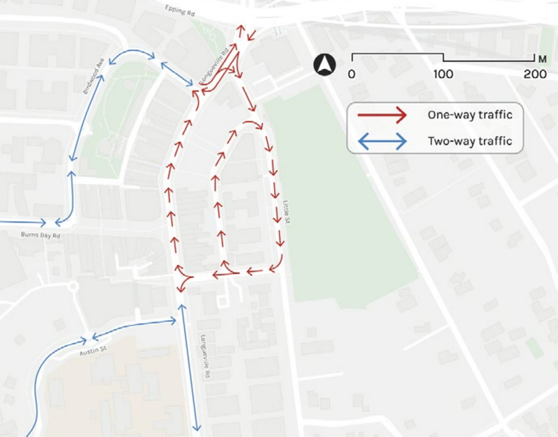
One of the most significant proposals is a low-speed shared space through the commercial heart of the Lane Cove Village. The DBP glossary defines a shared space as a street with a 10 km/h speed environment.
Its concept circulation plan shows a stretch of Longueville Road becoming one-way northbound and Little Street one-way southbound. The DBP notes the changes would retain Longueville Road vehicle access and not remove car parking, while reorganising traffic movements. The implications for bus stops and routes, loading and delivery arrangements, and emergency access require further assessment. These are concept proposals, not final detailed designs.
River Road and Burns Bay Road
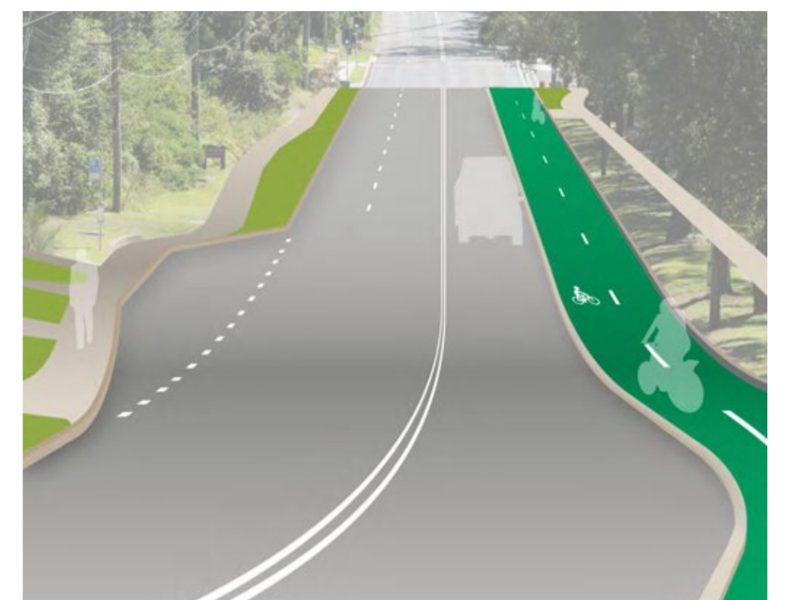
Separated bike lanes are proposed along Penrose Street, Bridge Street and River Road, and along Centennial Avenue and Burns Bay Road. These are the regional routes linking Lane Cove to North Sydney and Hunters Hill. The draft includes concept designs and cross-sections for both. This means that a lane is proposed to be closed. As the separated bike path is close to a set of lights and on a regional road, Transport for NSW would have to approve the bike path.
Quietways
These are local streets where riders share the road with traffic and travel in the centre of the lane. Speeds are kept below 30 km/h through street design.
The Plan also proposes safer crossings, more bike parking, and a target to double the proportion of students who ride to school.
Read the DBP here to see the full list of recommendations.
Community Consultation So Far
Lane Cove Council ran an early consultation round in February 2026, using a survey, interactive map, pop-up stall, community workshop and Bicycle Advisory Committee workshop.
It received more than 500 contributions, including 281 survey responses and 242 map pins identifying desired routes and safety concerns.
The Bicycle Advisory Committee, which advises Council on paths, facilities and the Strategic Bicycle Plan, has been part of that process.
Timeline and Funding
Each route was scored on how much it is needed (network connections, the destinations it serves, likely growth in riding, and safety) and on how easily it can be delivered (complexity and cost). The local routes were then grouped into three delivery phases.
| Phase | Timing | Length | Estimated cost |
|---|---|---|---|
| 1 | Next 3 years | 6.5 km | $5.2m |
| 2 | Years 4 to 6 | 9.0 km | $5.7m |
| 3 | Year 7 onwards | 6.1 km | $5.1m |
Phase 1 includes Longueville Road, the local section of Burns Bay Road, Tambourine Bay Road, and a neighbourhood route from Helen Street to Landers Road.
The four regional routes are not allocated to any delivery phase. They are Centennial Avenue and Burns Bay Road, the Pacific Highway, Penrose Street–Bridge Street–River Road, and Mowbray Road. Each is subject to funding.
Together they account for about $10.9 million, or 41%, of the Plan’s estimated $26.8 million construction cost. The draft regards these routes as high priorities, but says they require funding assistance and coordination with the NSW Government. The construction estimates are expressed in 2024 dollars, although delivery is proposed over the next decade.
Burns Bay Road and parts of Centennial Avenue are State roads under TfNSW. The Plan notes any upgrade will need TfNSW’s collaboration and further investigation. In practice, delivering these regional connections depends on State Government decisions and funding.
If adopted, the Bicycle Plan commits Lane Cove Council to advocate for the routes, but adopting the Bicycle Plan will not by itself mean that Council can fund and construct them.
Blue Lines to Stay
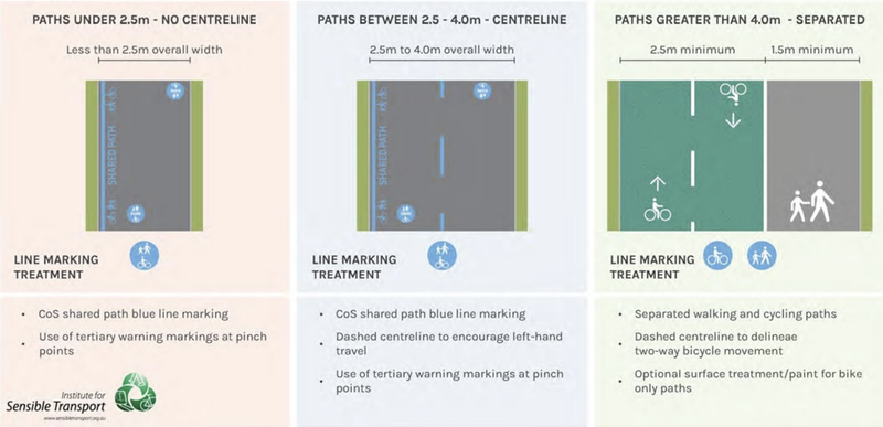
In October 2025, In the Cove reported that locals were not happy with the new blue line markings that had popped up over the Lane Cove LGA. You can read our article here.
The blue lines are referenced on page 77 of the report. See the explanation below. You can also make comments about the blue lines being included as part of the DBP.
How To Have Your Say
Feedback closes on Monday 9 November 2026. You can:
- complete the online survey on Council’s Have Your Say page, where the full draft can also be downloaded
- email a written submission quoting “Draft Bicycle Plan” to [email protected]
- post a submission to Lane Cove Council, 48 Longueville Road, Lane Cove NSW 2066.
Lane Cove Council has advised that the most useful submissions should be specific. Name the street, crossing or missing link. Say whether the problem is safety, connections, parking, conflict with pedestrians or access. Then describe the change that would make the route usable for an eight-year-old, an older rider, or someone riding to work.
After exhibition closes, Council staff will review submissions and prepare a final Bicycle Plan for Lane Cove Councillors to debate and consider. Bike Plans are reviewed every five years.
Support independent local news
In the Cove is 100% free to read, with no paywall, and it always will be. We write for the community, from within the community. If you value local news, chipping in helps keep it coming.
Proud member of LINA, the Local & Independent News Association. Want to reach locals? Advertise with us.