

At a Glance
- Then and now: just under 20,000 people lived in the Municipality of Lane Cove at the 1947 census. Today’s LGA holds about 43,000.
- Biggest change: the streets behind Mowbray Road in Lane Cove North, detached houses and a block of bush in 1943, now walk-up flats standing across three or four of the old house lots at a time.
- The lost trotting track: the 1943 frame of Lane Cove West shows an oval racing track in the bush where the business park now stands. Newspapers from 1930 put the Lane Cove Motor Cycle Club’s Sunday meets at “the trotting track” at Lane Cove.
- Least change: Greenwich Point still sits on the street grid and lot boundaries it had in 1943.
- Bush that held on: the bush along Stringybark Creek, once quarried for building stone, has kept its ground while the streets filled in around it.
- Still changing: St Leonards South, rezoned in 2020 for roughly 2,000 new dwellings, is still a street of houses in the current frame.
- Your school, then and now: seven local schools across eight sites, compared frame by frame, as Lane Cove Public School turns 150 and its students campaign to bring Nicole Kidman back through the gates on 7 August. One of those sites, in 1943, was somebody else’s school entirely.
- The comparison: nine corners of the LGA, each photographed in 1943, ten interim years, and the present day, plus a wide 1943-to-today slider that lines the whole LGA up street for street.
- Find your street: every frame is free to browse and download, and we want to know what you find in yours.
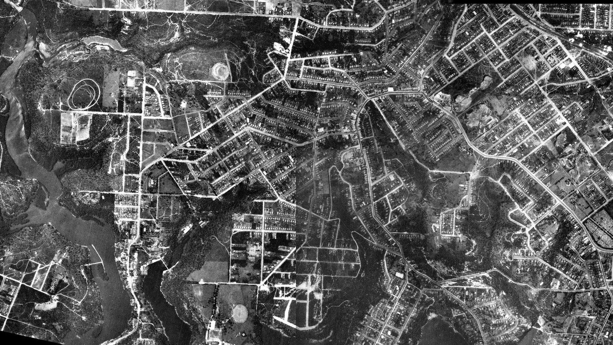
That is Lane Cove in 1930, photographed from an aeroplane and stitched together from two survey plates. The river runs down the left. The village sits in the middle, a few streets deep. Almost everything else is paddock, bush and the pale scratch of unmade roads, and if you look to the left of the village you will find a racing track cut into the scrub, which is a story we will come back to.
NSW Spatial Services has put its historical aerial archive online, free to browse frame by frame, and these are the oldest frames it holds over Lane Cove. What follows is the same ground photographed again and again across the next ninety-six years: nine corners of the LGA, the schools, and a slider you can drag to put 1943 against today.
The photograph above merges two frames from neighbouring flight lines of the same 1930 survey, one centred over Lane Cove and one over Greenwich, aligned by matching features across the overlap. Click it, or open it here, to see the full uncropped merge at full resolution.
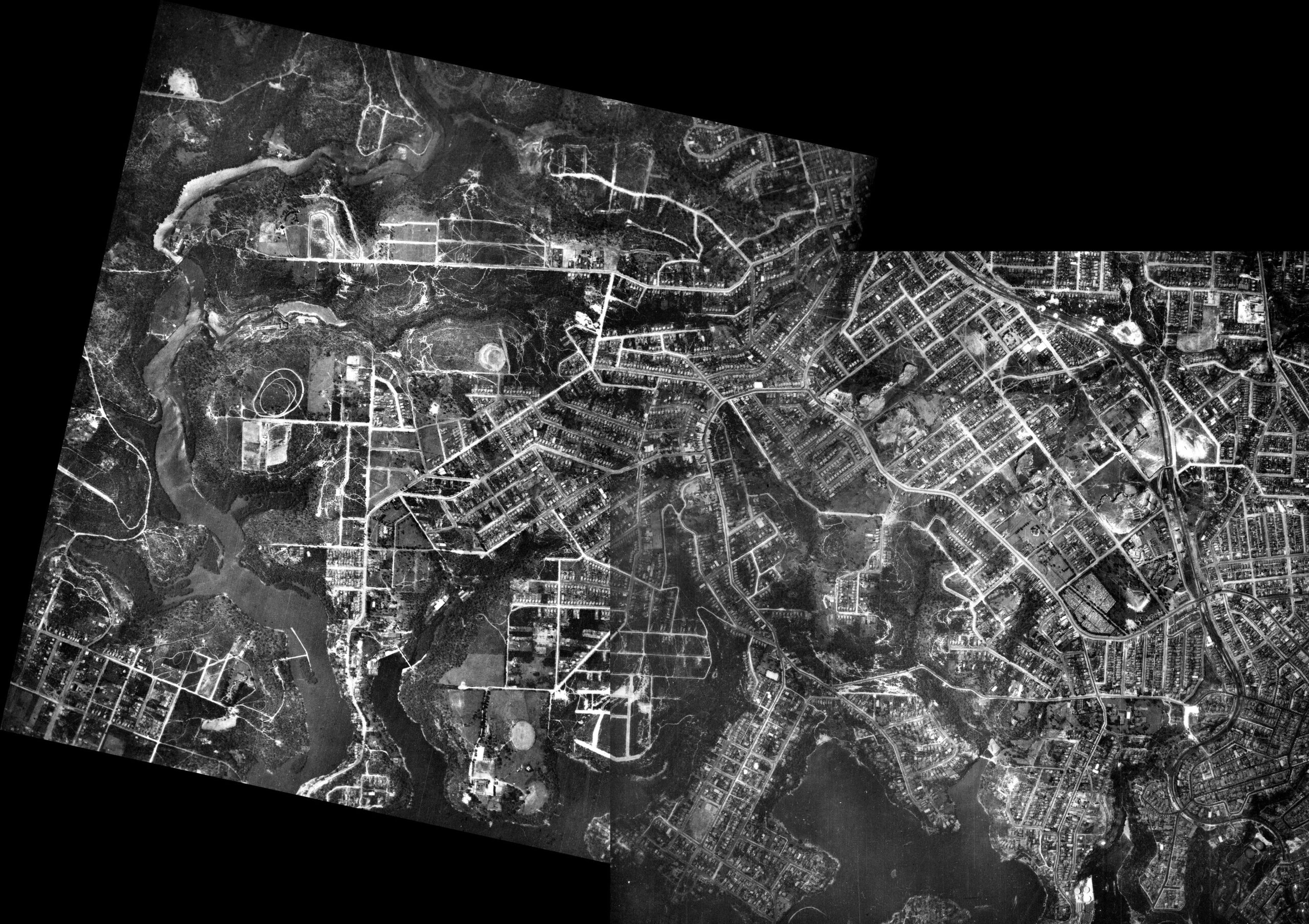
The Widest View: Lane Cove in 1930
The land in that photograph had been worked for a century, hard in patches and barely touched in between. Margaret Farlow, writing for the Dictionary of Sydney, records that “Bluegum, stringybark, blackbutt, red mahogany and turpentine were all prized by early timber-getters”, and that orchards and dairies were the district’s main rural industries. Two potteries worked clay at the head of Gore Creek in the 1880s, turning out teapots, Toby jugs and money boxes, and Pottery Green is named for them. There were tanneries on Burns Bay from 1858. Burns Bay Road itself is not an engineer’s line at all: it follows the route a timber-getter’s bullock carts took, dragging logs down to the river.
Growth came slowly. The 1901 census found barely 2,000 residents in 301 dwellings; by 1914 there were 4,600 people. The Harbour Bridge opened in 1932 and made the trip to town easy, but the Depression held building back, which is roughly the moment this photograph catches.
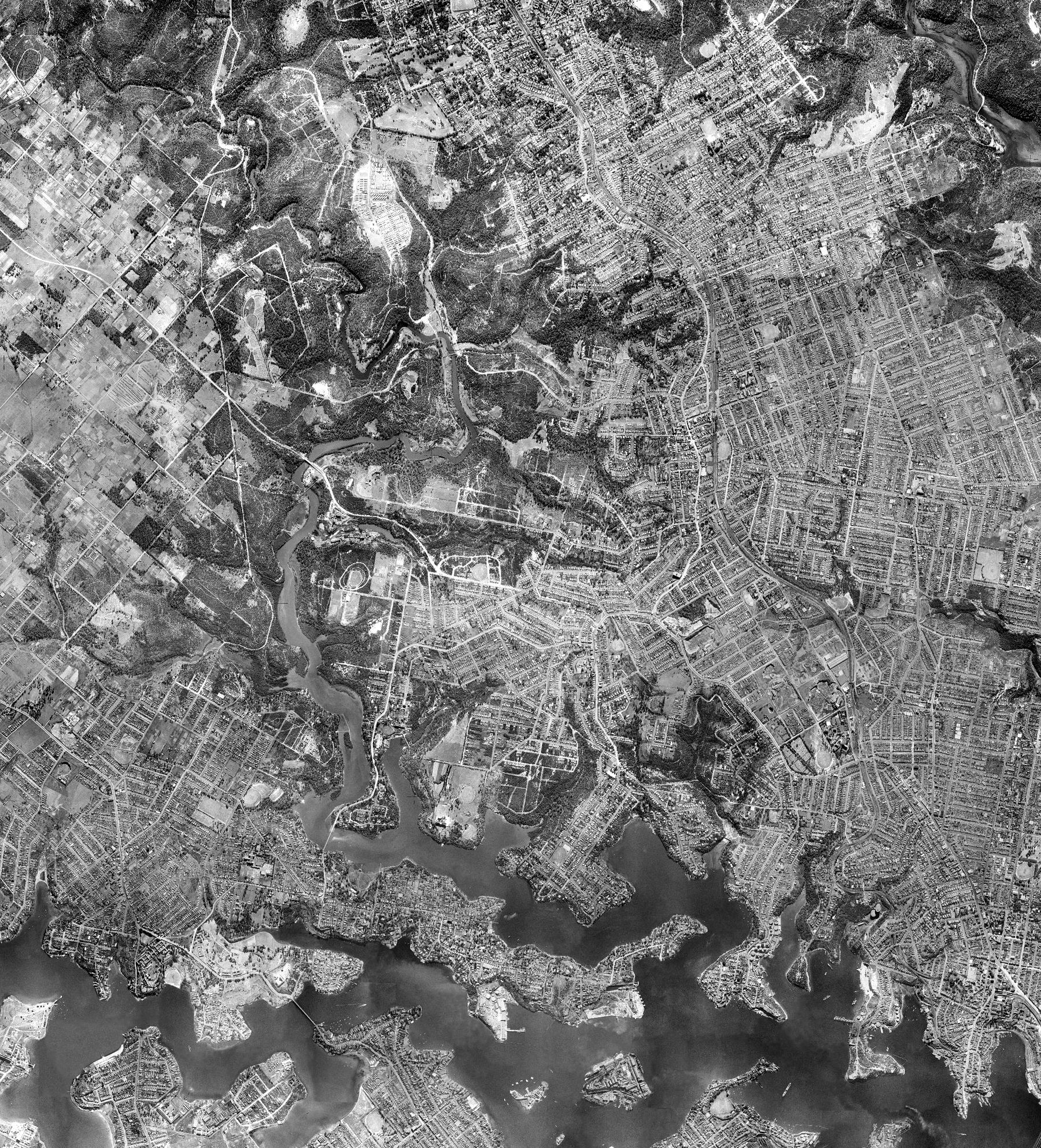
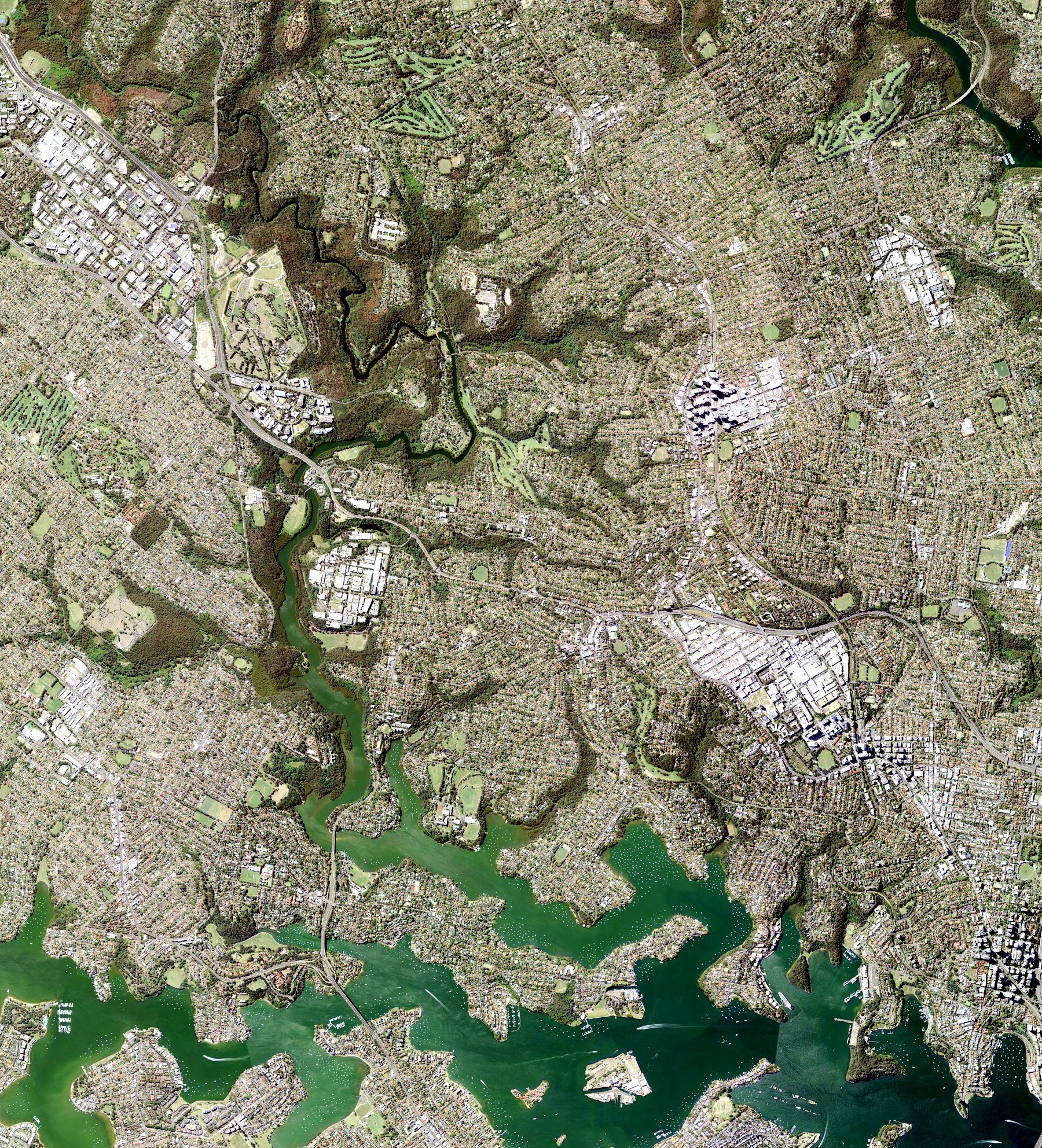
The 1930 plates are ordinary photographs, not maps, so they do not lay neatly over a modern aerial. To see the change street by street we skip forward to the next survey. Below is the same country in the NSW rectified aerial mosaic of 1943, paired with today’s orthophoto at the identical extent. (The frames over Lane Cove were flown in mid-1942 and published as part of the state’s Sydney 1943 mosaic, which is how they are catalogued.) Both are corrected for tilt and scale, so every road, river bend and shoreline lines up between the two eras. Drag the divider.
Lane Cove in 1943 and today
1943 Today
Drag the divider. The historical panel is the NSW Sydney 1943 aerial mosaic; the modern panel is NSW LPI Best Imagery. Both are orthorectified and shown at the identical geographic extent, so every street, river bend and shoreline lines up exactly between the two eras. The 1943 survey, thirteen years after the plates above, still shows a Lane Cove of bushland, farmland and a small village core. Both layers are published by NSW Spatial Services.
When that 1943 survey was flown, Lane Cove was a municipality of fewer than 20,000 people; the 1947 census counted 9,470 men and 10,347 women, 19,817 people in all. The latest ABS estimate puts the LGA at 43,094. The municipality more than doubled its people, and the aerials show exactly where it put them.
Nine Corners of Lane Cove
Lane Cove from the air looks like a quilt. Nine corners of it tell most of the story, and we have laid them out as a walk: starting up on the northern boundary and working down to the water. Each was photographed in 1943 and in ten later years, and each pair below shows the 1943 frame on the left and the same ground today on the right.
Nine corners of Lane Cove, 1943 to today
Location
Year
1943 Today
Imagery: NSW Spatial Services, © State of New South Wales, released under CC BY 4.0.
Lane Cove North: the flats behind Mowbray Road
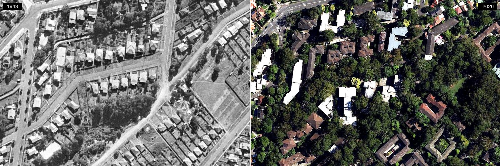 1943 (left) and today (right). Click the photograph to open it full size. NSW Spatial Services, CC BY 4.0.
In 1943 this is detached houses on a formed street grid, with a scrubby block still sitting undeveloped in the middle and an unmade road cutting across it. Mowbray Road runs along the top of the frame, and the flats went in on the streets behind it. In the current frame, walk-up blocks in U and courtyard shapes stand on the same ground, car parks tucked inside them, set back under heavy tree canopy. The streets kept their lines. The lots did not: a single block of flats now covers three or four of the old house frontages.
Lane Cove North: Stringybark Creek
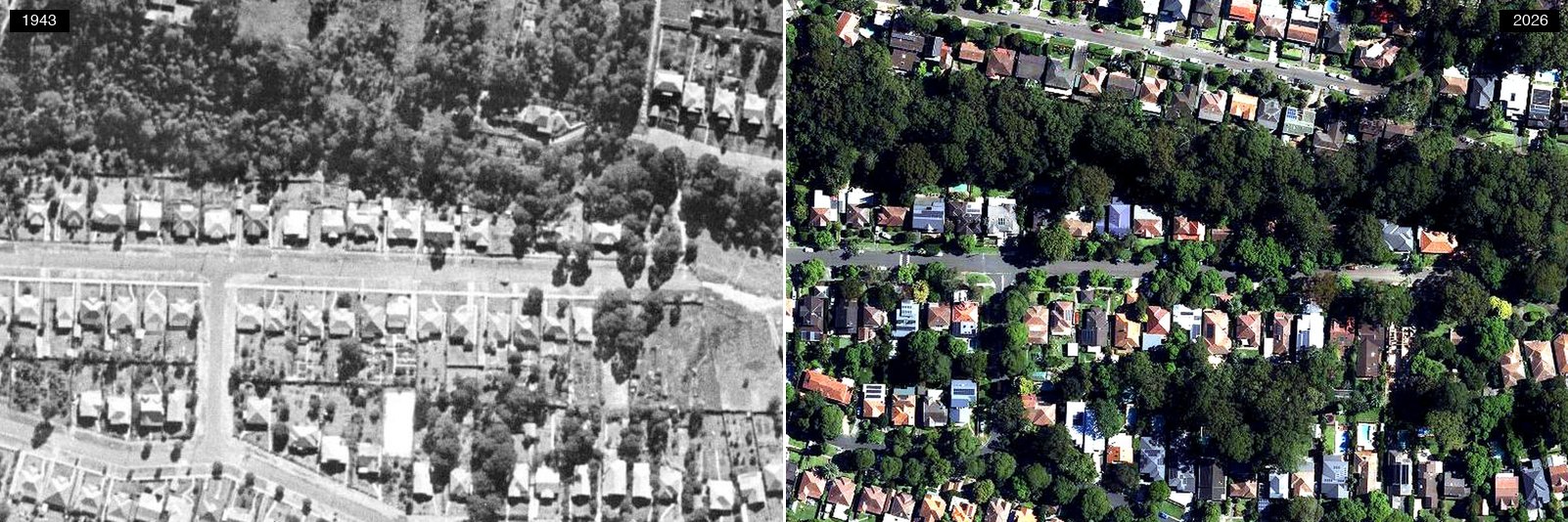 1943 (left) and today (right). Click the photograph to open it full size. NSW Spatial Services, CC BY 4.0.
The other side of Lane Cove North. This is the one corner of the nine where the green holds the line. Stringybark Creek runs in a gully, and the bush along it survived while the streets filled in on both sides: in the 1943 frame the houses are already marching up to the tree line, and in the current frame they have gone no further. The reserve has its own industrial history, a sandstone quarry that supplied stone to build up Centennial Avenue across the creek, and the walking tracks still pass its face. Lane Cove Council was among the first in the state to take bush regeneration seriously, adopting the Bradley method in the late 1970s. Everywhere else in this article changed by decision. This changed by being left alone.
Lane Cove West: the trotting track under the business park
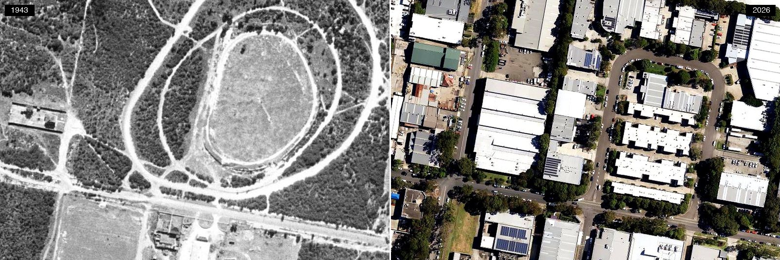 1943 (left) and today (right). Click the photograph to open it full size. NSW Spatial Services, CC BY 4.0.
The strangest frame in the set. In 1943, where the business park now stands, there is a racing oval cut into the bush, ringed by concentric tracks, with paddocks to the south. It appears to be the trotting track that Sydney’s motoring pages placed at Lane Cove: in 1930 the papers listed the Lane Cove Motor Cycle Club’s Sunday meets there (“Lane Cove M.C.C. — Sunday, speed judging test, trotting track, 9.30 a.m.”, ran one 1930 club-events column), and by 1937 a report of two Naremburn men hospitalised after their motorcycle and sidecar capsized described it as “an old trotting track at Lane Cove”. By 1955 the bush around it had been cleared and the first factories had reached its western edge, though the oval’s outline was still legible on the ground.
Then the postwar planners arrived: a Macquarie University history records that council, needing an industrial zone, chose “the unwanted land in Lane Cove West (with prime river views)”. The track vanished under factories. Festival Records pressed vinyl here from the mid-1950s; Life Savers ran a Mars Road plant its 1963 annual report claimed was the most modern confectionery works in the Southern Hemisphere, and Salvatore Nicotra was one of the first to help make Quick-Eze there. Today the ground around it holds the LGA’s data centres: five built, approved or in planning in the Lane Cove West business park. Horse track, motorbikes, vinyl, lollies, the cloud: one paddock, five economies.
Lane Cove village: the Plaza
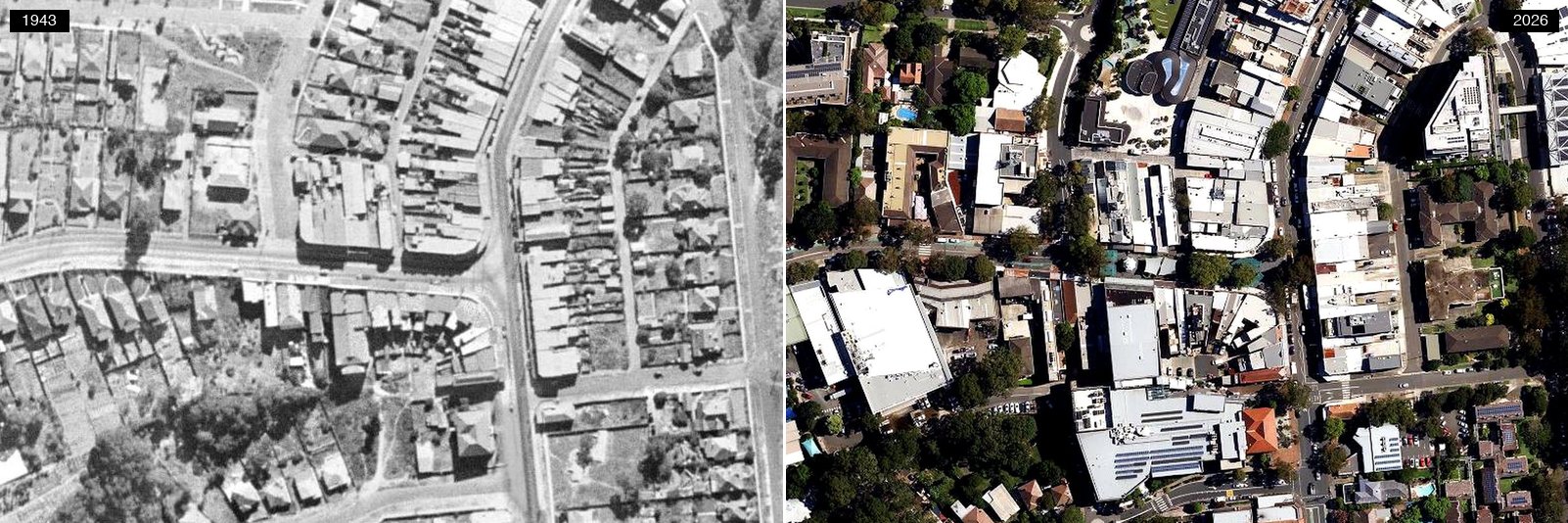 1943 (left) and today (right). Click the photograph to open it full size. NSW Spatial Services, CC BY 4.0.
The street grid in the village has held its shape for eighty years; what changed is what sits on top of it. The 1943 frame shows a low street of shops and houses. Farlow’s history records that “The first block of flats was built in 1962 and by 1979 nearly 200 blocks of flats had been built along the main roads around the Lane Cove village.” The Plaza came in 1977, the first pedestrian mall in NSW created by closing off part of a main street, a move the Dictionary of Sydney notes was regarded at the time as “a bit radical”. The library beside it has been on its corner since 1962, in the converted 1924 Council Chambers, and moved into its current building in 2010.
Riverview: the suburb on the point
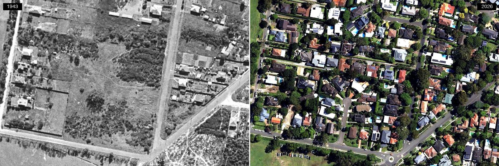 1943 (left) and today (right). Click the photograph to open it full size. NSW Spatial Services, CC BY 4.0.
Riverview takes its name from an estate that was already called River View before the Jesuits bought it in 1878, and it stayed paddock long after the rest of the district had streets. The 1943 frame shows it: a wide open block ruled into rectangles by fence lines, with a cluster of small houses along its eastern edge and a scatter more around the rest. More farm than suburb. Most of that ground today is roofs and mature canopy, though a broad band along the western edge is still open playing field, exactly as it was then. Riverview was not gazetted as a suburb in its own right until 1976, which is late for a place this old, and the shape of it is really the shape of one large estate slowly broken up. When Salvatore Nicotra bought his house in Hamilton Street in 1960, his friends told him not to buy in Lane Cove because it was too far from the city, In the Cove’s profile of him records. When In the Cove visited for his 90th birthday in 2024, he was still in the same house.
St Leonards South
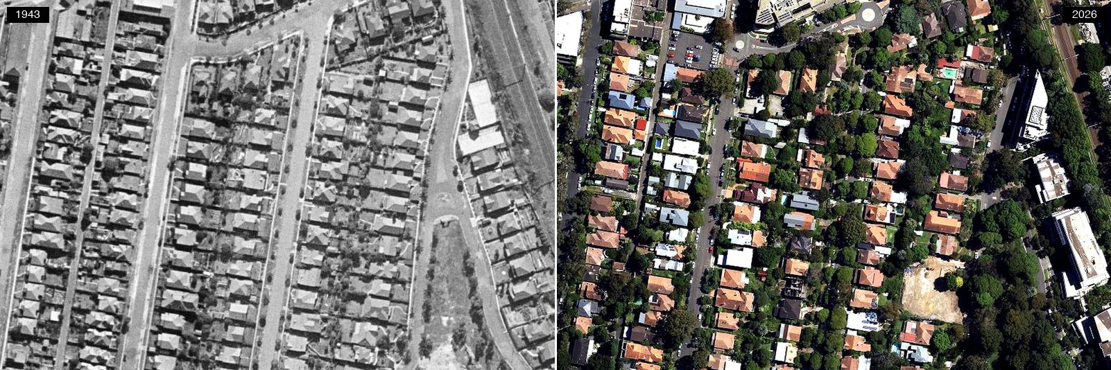 1943 (left) and today (right). Click the photograph to open it full size. NSW Spatial Services, CC BY 4.0.
The corner of Lane Cove where the change is still happening. From 1943 to 2005 the area held a steady pattern of houses on small blocks. The 2020 rezoning to high-density residential opened the way for roughly 2,000 new dwellings. What the current frame catches is the moment before: the same rows of houses, gardens and pools, with the towers of St Leonards standing over the back fence and the first cleared blocks waiting.
Longueville: the Woodford Bay waterfront
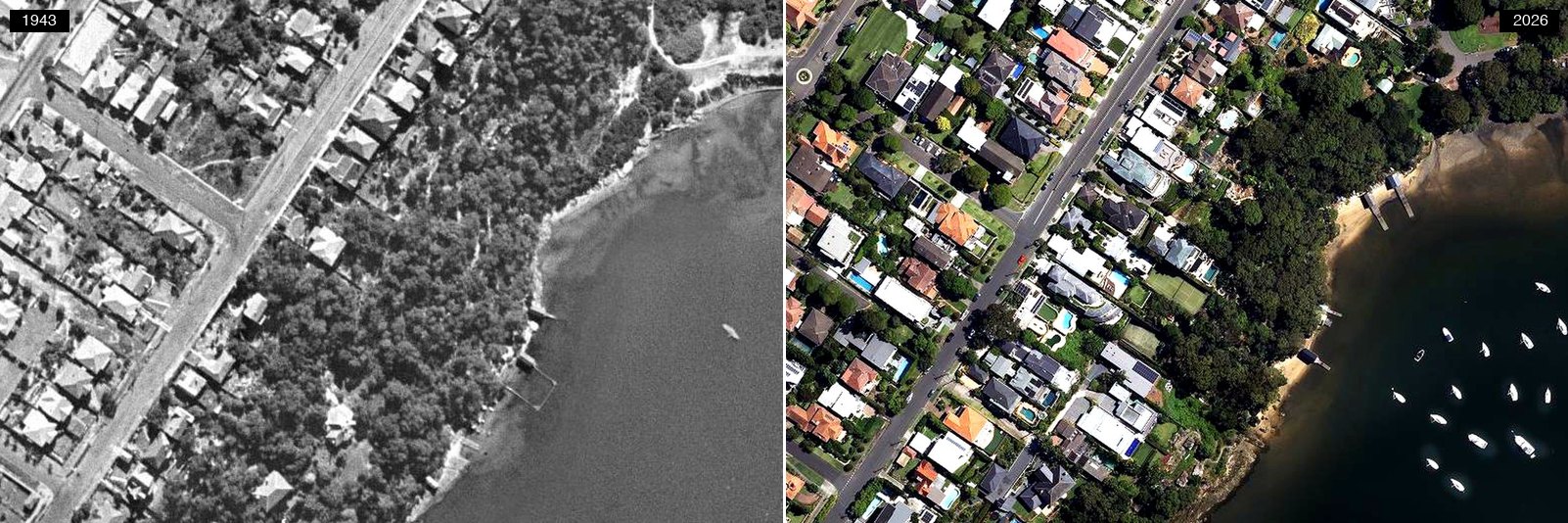 1943 (left) and today (right). Click the photograph to open it full size. NSW Spatial Services, CC BY 4.0.
The streets inland were already drawn and already lined with houses in 1943. It is the ground nearest the water that was still waiting: in the older frame the slope down to the bay is bush, carrying a scattering of roofs and a couple of jetties. That slope is now a solid run of houses with pools. What has not moved is the water’s edge itself, and the belt of bush above it, now Woodford Bay Reserve. This was orchard country once, right across the river suburbs; Farlow’s history names William Pendry of Northwood as one of the district’s earliest orchardists, with about 20 acres of stone fruit.
Northwood: the point at the end of the road
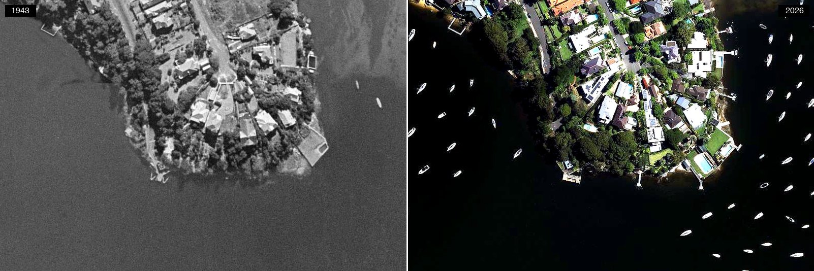 1943 (left) and today (right). Click the photograph to open it full size. NSW Spatial Services, CC BY 4.0.
Northwood was already Northwood in 1943. The point at the end of the road is subdivided and built on, a dozen or so houses stepping down to the water, a road along the spine, jetties on both shores. The current frame has larger houses, pools and solar panels on the same lots, held by the same shoreline. What changed is the water. In the 1943 frame you can count the boats off the point on one hand. Today they are moored in ranks on both sides, Woodford Bay to the west and the open river to the east.
Greenwich Point peninsula
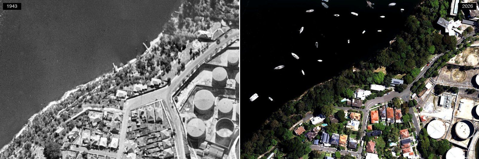 1943 (left) and today (right). Click the photograph to open it full size. NSW Spatial Services, CC BY 4.0.
The control case. The lot pattern of 2026 is already there in 1943: same street grid, same foreshore, same bushland edges. The Point filled early and it filled small, a village of about sixteen houses in 1884, with brickmaking from the 1870s and three quarries by the 1880s. The industry never entirely left. Those round tanks on the right of both frames are the Gore Bay oil terminal, which despite the name sits on Gore Cove, and which Viva Energy dates to 1901. Not tank for tank, though: several of the 1943 ones have gone, leaving pale rings where they stood. Frame by frame, the same place wearing different cars.
Your School, Then and Now
Nowhere holds more Lane Cove memories per square metre than a schoolyard, so we cut the same before-and-after views for seven local schools across eight sites. Each pair below shows the 1943 frame on the left and this year on the right. Spot what moved.
Your school, 1943 to today
School
Year
1943 Today
Imagery: NSW Spatial Services, © State of New South Wales, released under CC BY 4.0.
Lane Cove Public School: 150 years young
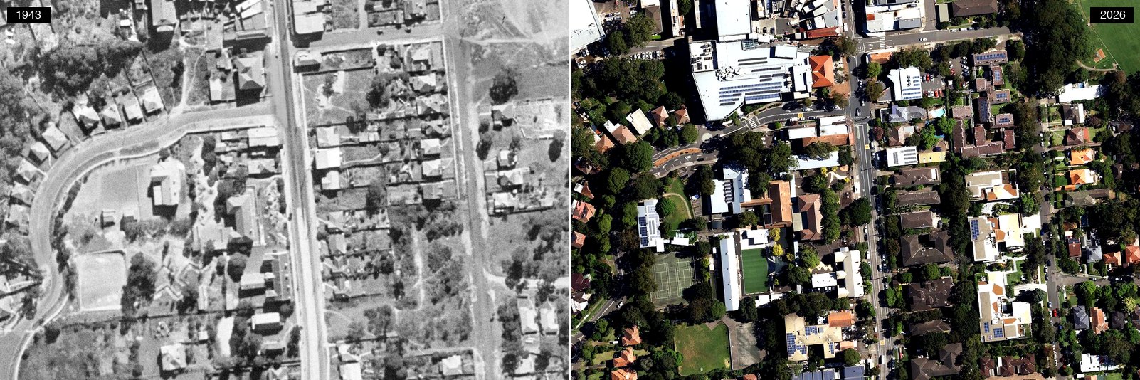 1943 (left) and today (right). Click the photograph to open it full size. NSW Spatial Services, CC BY 4.0.
The block already carries buildings and bare play ground in the 1943 frame, when the school was in its seventh decade; today’s campus fills the same corner with its courts and the bright green of the synthetic surface. The timing of this one is no accident. Lane Cove Public School was established in 1876 and turns 150 this year, with an on-site public event on Friday 7 August 2026: displays, performances, and a chance for former students and families to come back through the gates. “We want to honour our past, celebrate our present, and look to the future,” principal Terry McKinnon told In the Cove. The students have gone one better and made a video inviting Nicole Kidman, once an LCPS pupil herself, to come along.
St Michael’s: the school built over a school
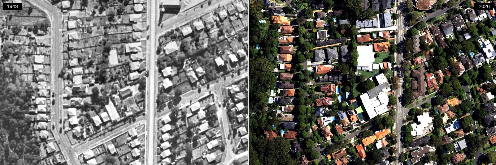 1943 (left) and today (right). Click the photograph to open it full size. NSW Spatial Services, CC BY 4.0.
St Michael’s started life on the other side of the road. The parish’s first church-school was blessed by Archbishop Kelly in August 1919, on the Dorritt Street land the parish still occupies, and that building survives as the Dorritt Street hall. The Sisters of Mercy, who had taught the children since 1922, established a convent in Lane Cove in 1928, and the campus on the western side of Longueville Road took its modern shape on a Sunday in May 1953, when a new two-storey school was opened next door to that convent.
Currambena: the street that stood still
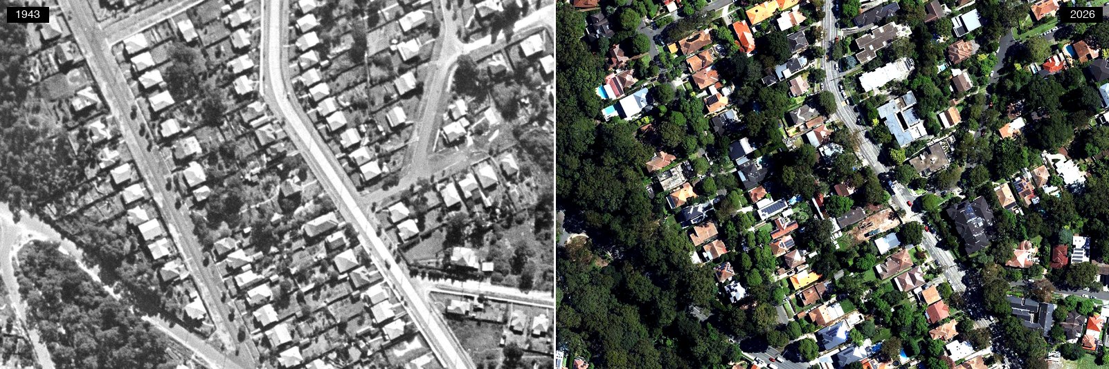 1943 (left) and today (right). Click the photograph to open it full size. NSW Spatial Services, CC BY 4.0.
The quietest pair in the set, and that is the point. The stretch of Longueville Road where Currambena now runs its classrooms was already built by 1943, and the streetscape around it is recognisably the same eighty years on. Some corners of Lane Cove changed by demolition; this one changed by moving new life into old rooms.
Greenwich Public School, Greenwich Road: the campus that was there
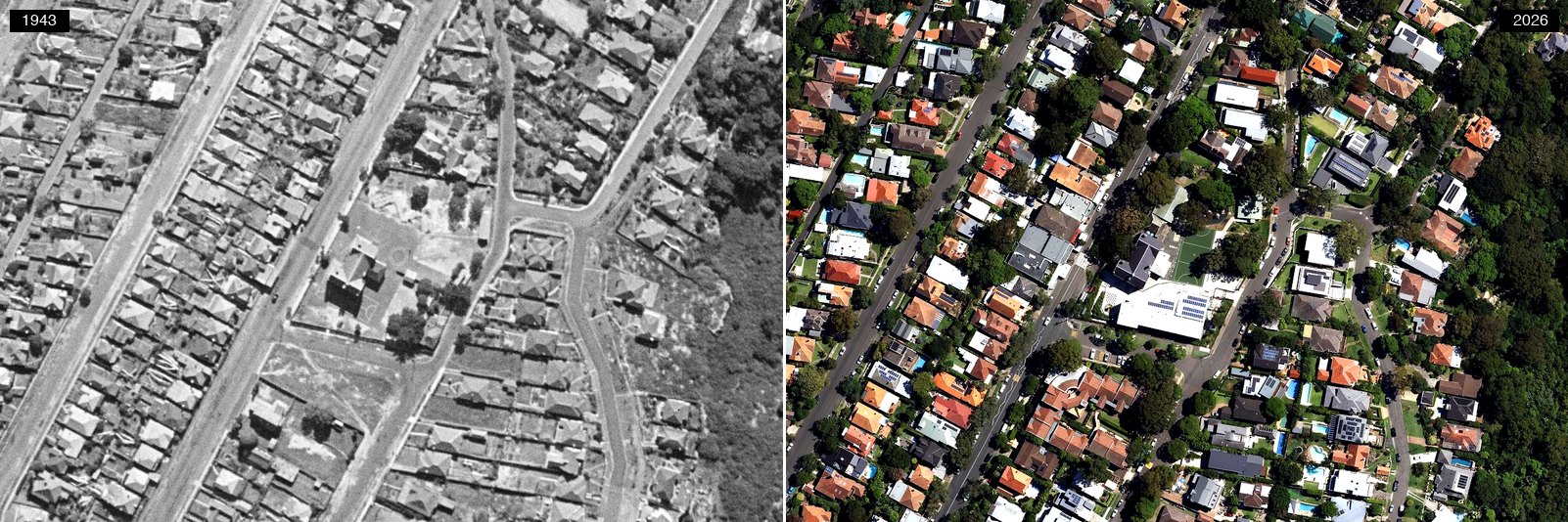 1943 (left) and today (right). Click the photograph to open it full size. NSW Spatial Services, CC BY 4.0.
Greenwich Public School runs across two campuses, roughly a kilometre apart by road, and only one of them was its own in 1943. This is the older half, the Kindergarten to Year 2 site on Greenwich Road, and in 1943 it was the school’s only site. A two-storey building with five classrooms was completed here in 1909, arranged so two rooms on each floor could be merged if a teacher was away. One former pupil, Ian Spencer, recalls in the school’s history that by mid-1943 an air raid shelter had been dug on the boys’ side of the yard, with steps down to a barred gate and wooden seats along a tunnel; it was never needed, which was just as well, since it seems to have had no ventilation. In the 1943 frame the large building and its cleared playground sit on a block still doing the same job today.
Greenwich Public School, Kingslangley Road: somebody else’s school
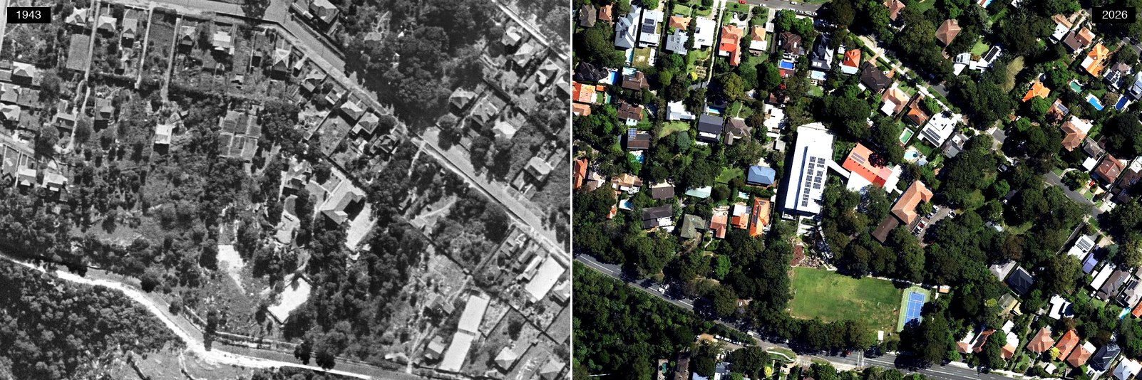 1943 (left) and today (right). Click the photograph to open it full size. NSW Spatial Services, CC BY 4.0.
In 1943 the Years 3 to 6 campus on Kingslangley Road was not a public school at all. It was Hillcrest, a private day and boarding school for boys and girls, advertising from the same street number the campus uses today and describing itself as conducted “on Christian Science principles”. Hillcrest closed before Christmas 1949. In February 1950 the Minister for Education announced the government had resumed its buildings and land, gazetting the resumption before tenders for sale of the property closed; the report described more than five acres running back to River Road, with two tennis courts and a small oval. The villa-like building group in the 1943 frame is Hillcrest. The public school arrived seven years after the photograph.
Lane Cove West Public School: a school on the paddocks
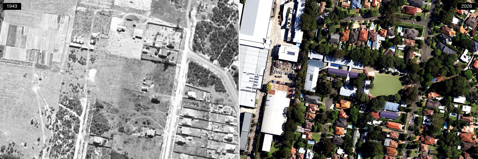 1943 (left) and today (right). Click the photograph to open it full size. NSW Spatial Services, CC BY 4.0.
In 1943 this is open paddock country, cultivation rows still legible at the frame’s edge, with a scatter of sheds. Today the same ground holds a full campus, oval and all, hard up against the business park. Of all the school sites here, this is the one built most completely on farmland.
Saint Ignatius’ College Riverview: the fields that stayed fields
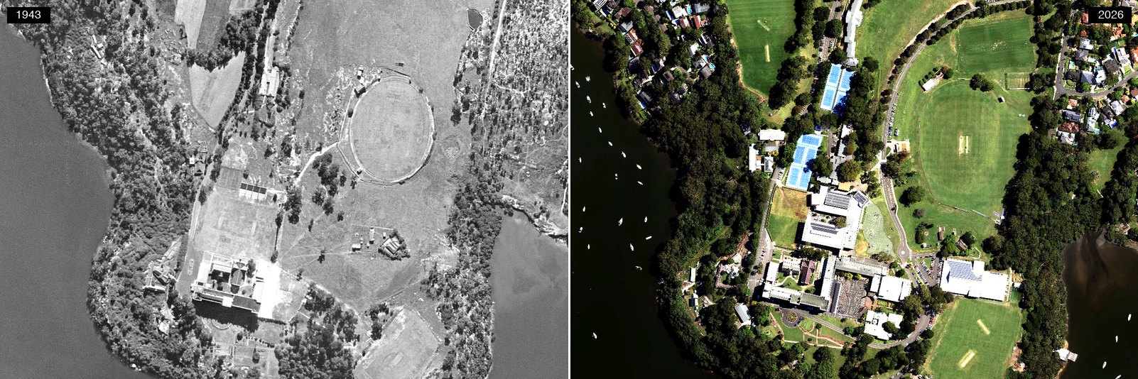 1943 (left) and today (right). Click the photograph to open it full size. NSW Spatial Services, CC BY 4.0.
In 1943 this is open ground: bare playing fields, a running track cut into the grass, a few sheds, and the dark line of bush along the river. Today the same ground carries the college’s tennis courts, its buildings and their solar roofs, and an oval kept green through summer. The playing fields are still playing fields, which is the point. The Jesuits bought the property in 1878, when it was already called River View, and the school has since given its name to the suburb around it rather than the other way about.
Mowbray Public School: the boom school
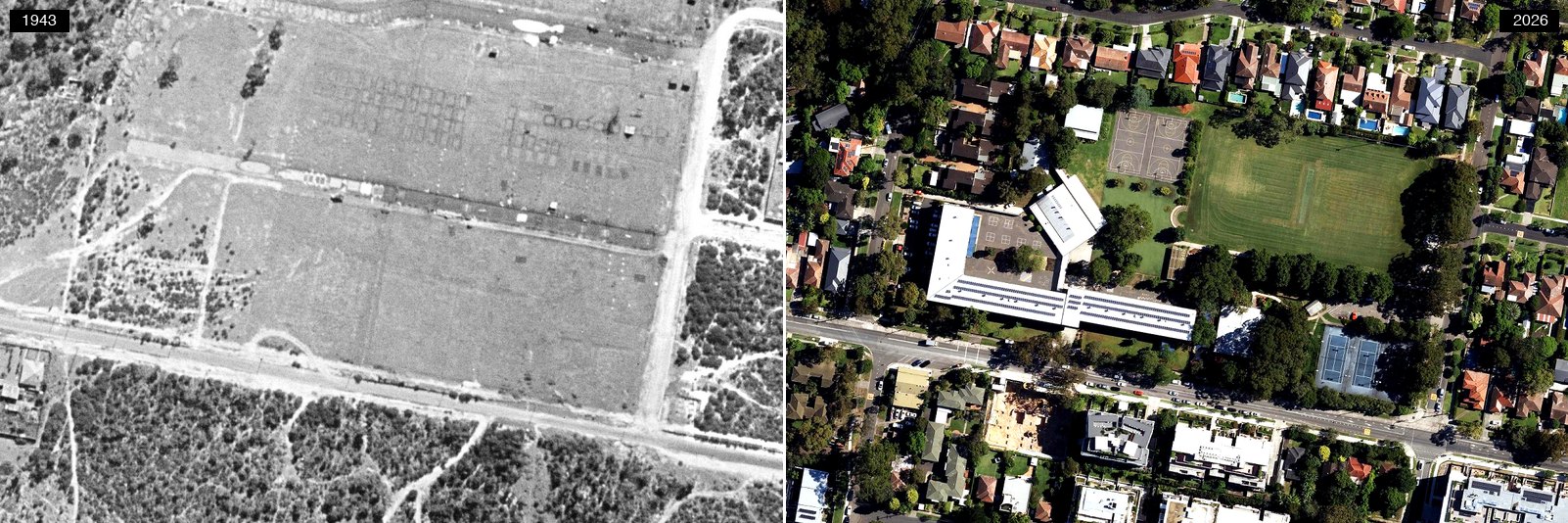 1943 (left) and today (right). Click the photograph to open it full size. NSW Spatial Services, CC BY 4.0.
The 1943 frame shows cleared ground with faint regular rows still legible in the soil. Today it is a large modern campus with a full-sized field, and the growth is not just in buildings: Mowbray was the standout in our school enrolments analysis, nearly doubling from 378 students to 700 in a decade while enrolments fell across most of the lower North Shore.
Find Your Street, Then Tell Us
The corners above cover a fraction of the LGA. The archive covers all of it, at every scale, and the NSW Historical Imagery Viewer is free:
- Search: type your street into the search box in the top right and navigate to your block.
- Browse the frames: toggle the Imagery Index layer to see every historical frame that has captured your house, with the date and a high-resolution download.
- Mind the gaps: the frame-by-frame record over Lane Cove is uneven, thinning out through the 1970s and 1980s, and the index stops at 2005, after which you are on the current imagery layer. The seamless year-by-year mosaics cover fewer years than the individual frames do.
Then come back and tell us. Was your house there in 1943? What stood on your block before it? Screenshot your street’s oldest frame and email it to [email protected] or post it in the comments; we will publish the best finds in a follow-up.
This article was written by Anthony El-Khoury as an unpaid contributor. Data collection, analysis, and visualisations were completed with the assistance of AI, with all claims checked against the cited sources. The views expressed are his own and not those of his employer.
In the Cove delivers independent Lane Cove news every day — 100% free, with no paywall. Your support helps ensure Lane Cove continues to have a strong, independent voice.
Support In the Cove: ☕ Shout ITC a Coffee or ❤️ Contribute Any Amount or 📣 Advertise with Us
Sources: aerial imagery from the NSW Historical Imagery Viewer and NSW Spatial Services’ SIX Maps, all © State of New South Wales (Spatial Services) and released under Creative Commons Attribution 4.0. Historical detail from the Dictionary of Sydney’s Lane Cove entry by Margaret Farlow and its Greenwich entry by Prudence Macleod; Lane Cove Council’s history of the area; Lynne McLoughlin’s The Middle Lane Cove River: A History and a Future (Macquarie University, 1985); 1930s newspapers via the National Library’s Trove archive (Daily Pictorial, 30 August 1930; The Sun, 5 September 1930; Labor Daily, 6 September 1937). Population figures from the ABS 1947 census LGA tables and Regional Population 2024-25. Salvatore Nicotra’s story from In the Cove’s 2024 profile; library dates from In the Cove’s 70th-birthday history; the Nicole Kidman campaign from our July round-up and the students’ video invitation; school enrolment trends from our schools analysis; St Michael’s from the Sydney Morning Herald, 25 August 1919 and 21 July 1953, the Catholic Weekly, 7 May 1953 and Construction, 22 July 1953, with the Dorritt Street hall, the 1928 convent and the 1976 church from the parish’s own history and St Michael’s Catholic Primary School; demographic trends from our census deep-dive; Lane Cove Public School’s 150th from In the Cove, 14 May 2026; Greenwich Public School’s two campuses, its 1909 building and Ian Spencer’s air-raid-shelter recollection from the school’s own history; Hillcrest from the Newcastle Morning Herald, 6 September 1940 and the Sydney Morning Herald, 25 February 1950.